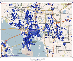
Engineers have developed a system for taking anonymous cell-phone location information and turning it into an illuminated traffic map that identifies congestion in real time. The system takes advantage of the steady stream of positioning cues–untraced signals all cell phones produce, whether in use or not, as they seek towers with the strongest signals. It is the first traffic-solution technology that monitors patterns on rural roads and city streets as easily as on highways.
Developed by IntelliOne of Atlanta, Ga., the TrafficAid system could not only help guide drivers around tie-ups, but also tell emergency responders where accidents are or how effectively an evacuation is unfolding by pinpointing clusters of cell phones.
Because TrafficAid does not use personally identifiable data, the servers that generate position and traffic information do not know whose phone is showing up in the data stream, only that a particular phone at a given location is moving at a given speed.
From this information, IntelliOne uses its Mobile Positioning System (MPS) to convert ordinary signaling data into phone locations at a rate of two times per second, which in turn is passed to the company’s Traffic Determination Engine (TDE), where each phone is matched to the correct road and monitored with other phone locations to produce average speeds and travel times for all roads with cell coverage.
Finally, a legit reason for having a GPS and real time info in a vehicle. I can see this being added to emergency vehicles right off the bat.


IntelliOne is from Atlanta. I couldn’t think of a better place to test identifying traffice congestion!
Elwood
OLD News. Been happening in Europe for over a year. Yawn america http://www.mts-live.com/
Reminds me of listening to NPR this morning, and a story about new parking meters with “sonar”…
When the meter senses the car has left the parking spot, it resets the time remaining to zero – so the next person parking there can’t take advantage of the remaining time on the meter.
Idea being that cities can make more money by eliminating the “free” time the next person would get.
Portland, OR use of kiosk-printed parking stickers vice individual meters already does away with the “free” time – with no need for sonar.
Tie-in to the above article was that vacant meters could start transmitting their own location to drivers, and meters could SMS a parked car’s owner when the meter’s time is close to expiring.
Because TrafficAid does not use personally identifiable data, the servers that generate position and traffic information do not know whose phone is showing up in the data stream,
that we know about. Aren’t phone records supposed to be confidential as well?
Hmmm, what about a busy Starbucks at a corner showing up as a traffic tieup?
This is going to show areas with poor cell coverage pretty quickly. Just overlay a weeks worth of 24/7 data on the map. I would be interested in using this information to know what areas have good coverage, and which don’t — information that cell companies area loath to give out. The article says “snapshot from a single carrier’s network.” It would be interesting to compare the different cell providers coverage areas.
Oh yeah, the other advantage to the sonar-equipped parking meters – for the cities – is that they can inform the parking patrol when the time has expired and a car is still parked there.
Cops won’t have to make routine checks of the meters, they can just wait for the individual meters to send an alert.
The system takes advantage of the steady stream of positioning cues–untraced signals all cell phones produce, whether in use or not,…
… the servers that generate position and traffic information do not know whose phone is showing up in the data stream, only that a particular phone at a given location is moving at a given speed.
Nice for speed traps!
Keep the radar/laser off until the screen shows a speeding vehicle is within range…
It’s actually old news in the US as well, as several companies have looked at this for a number of years. Many of them have already considered and rejected the idea, at least as the primary method of identifying congestion. The problem is that while the theory is good, the information isn’t actually accurate enough to give meaningful measurements, and it’s inaccurate in multiple ways. You don’t know if it’s a driver or a pedestrian or a cyclist or someone in a slow-moving dump truck. You don’t know if it’s someone on a highway or a frontage road. You can’t measure speed of an individual signal with any accuracy. The simple task of snapping a blip to the “nearest feature” is not reliable, particularly near cities.
You can derive some information just from the presence of blips, and you can rely on the information a lot more in certain localized areas (like on bridges, where there aren’t any other nearby features). But most of the “safe to calculate” areas already have their flows directly measured by other means, just because of their importance. And in or near urban areas, the roads are too close together for meaninful results.