
Here’s one of the most amazing animations from NASA satellites I’ve ever seen. It portrays ocean surface temperatures from June 9 – August 9.
Satellites from NASA and the National Oceanic and Atmospheric Administration (NOAA) had a busy month in July following the five named storms in July: Cindy, Dennis, Emily, Franklin and Gert.
During July, 2005 NASA and NOAA investigators flew sophisticated research aircraft within and above several of these storms, as part of NASA’s Tropical Cloud Systems and Processes (TCSP). TCSP was undertaken to better understand the processes that lead to the birth and intensification of hurricanes.
“Hurricane Emily was the most powerful hurricane that NASA has ever flown over,” stated Dr. Jeffrey Halverson, Severe Weather Meteorologist, at NASA’s Goddard Space Flight Center, Greenbelt, Md. “Emily and Dennis were both strong hurricanes, meaning Category 3 or higher; it is highly unusual for two strong storms to develop in close succession as early as July in the Atlantic hurricane season.”
What was the reason for this record setting number of named storms? According to NASA satellite data, the winds and sea surface temperatures were perfect during the month of July to help these five tropical cyclones form.
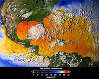
Unlike traditional infrared satellite instruments, the Aqua satellite’s Advanced Microwave Scanning Radiometer (AMSR-E) and the Tropical Rainfall Measuring Mission’s (TRMM) Microwave Imager can detect sea surface temperatures through clouds. This valuable information can help determine if a tropical cyclone is likely to strengthen or weaken. The Jason-1 satellite altimeter provides data on sea surface height, a key measurement of ocean energy available to encourage and sustain hurricanes.
Air temperature and humidity are also important factors. The Atmospheric Infrared Sounder (AIRS) experiment suite aboard the Aqua satellite obtains measurements of global temperature and humidity throughout the atmosphere. This may lead to improve weather forecasts, improved determination of cyclone intensity, location and tracks, and the severe weather associated with storms, such as damaging winds.
The TRMM satellite’s Precipitation Radar (PR) instrument provided by Japan for the TRMM satellite provides CAT scan-like views of rainfall in the massive thunderstorms of hurricanes.


A form of gambling could be created from posts like these. What’s the over/under on how many posts it will take for some crackpot to mention “global warming”?
I’d put it at 5.
Florida’s new role: incubator and initial test for killer hurricanes.
If hurricanes are caused by spinning columns of hot humid air, why do they not form over Washington DC?
Cause hyperbole oft spins in the opposite direction.