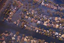
Aug. 31, 2005 — NOAA today posted online more than 350 aerial images of the U.S. Gulf Coast areas that were decimated by Hurricane Katrina. NOAA will be flying more missions in the days ahead that will yield hundreds of additional aerial digital images. The regions photographed on Tuesday range from Bay St. Louis to Pascagoula, Miss. The southeast coastal areas of Louisiana are being photographed on Wednesday.
The servers are often swamped. There are detailed views available — when you can get through.


IMO, they should just rename the place the “New City of Atlantis” and nix any ideas to restore the area as living in a bowl with global warming just seems to be asking for it again. Not to mention, I wouldn’t appreciate the US gov’t using my tax dollars to insure the occupants of the area the next time that it occurs which it would have to as any private insurer would be nuts to offer insurance in that drained hole.