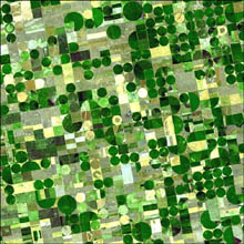
Each of these crops was at a different point of development when the Advanced Spaceborne Thermal Emission and Reflection Radiometer (ASTER) captured this image on June 24, 2001, accounting for the varying shades of green and yellow. Healthy, growing crops are green. Corn would be growing into leafy stalks by late June. Sorghum, which resembles corn, grows more slowly and would be much smaller and therefore, possibly paler. Wheat is a brilliant gold as harvest occurs in June. Fields of brown have been recently harvested and plowed under or lie fallow for the year.
Central pivot irrigation draws water out of a single well in the center of the field. Long pipes perched on wheels rotate around the pivot, showering the crops with water. Because the water falls directly on the crops instead of being shot into the air as occurs with traditional sprinklers, less water is lost to evaporation and more goes to nourishing the growing plants. Central pivot irrigation also creates perfectly circular fields, as seen in this image. The fields shown here are 800 and 1,600 meters (0.5 and 1 mile) in diameter.
The article has sensible content about the Ogallala Aquifer, as well.


I have seen some of these circles on Google Earth… was wondering why you would plant in a circle – now you explained it. When you doing a podcast dude? Love you on TWiT, spose I shouldn’t be posting my next comment here, but Leo said that Steve? was using a new skype technique and they would go into it later in the cast… never did – the quality was far superior to previous skype calls what was the trick and are you having any luck with yours?.
It’s amazing what the crrent ‘crop’ of satellite imagery (no pun) can give you! In addition to all the weird and wonderful stuff you never knew were there, a lot can now be done to ensure proper use of scarce natural resources.
For instance, my country (Portugal) is going through the most severe drought of the past 100 years, so naturally the government has started all sorts of campaigns to make us (the people) save water.
At the same time I recently found I inherited a small patch of land inside a nature reserve, which was always a very dry place to begin with.
Well, when I got there I saw everything almost dry alright. Then I went to Google Earth and found, to my amazement, *several* dozens of swimming pools – INSIDE A NATURE RESERVE – in a 5 mile radius, and a golf course less than 10 miles away…
So I got thinking – yeah, it’s a bad drought, but maybe we could survive alright if ALL people saved water!
Maybe when portuguese people finally wake up they’ll look at the photos and ask – why should WE be the only ones saving water? So that these guys can swim and play golf?
I hope satellite imagery becomes even more detailed and sophisticated so that people can start to identify these and other issues in more details, such as what kinds of crops are being grown.
Another big issue in Portugal has been forest fires. In addition to government corruption, a lot has to do with so much our our country now being covered with eucalyptus trees. Now this isn’t a native species, has no predators, sucks all the little water there is, and when it burns, it burns like hell, in such a way that nothing else survives a forest fire but… eucalyptuses… It’d be nice to see all the places where these trees have been planted without having to pay for a hugely expensive air survey, and then start fighting the good fight against these trees and the easy money that comes out of them.