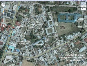
I’m not sure why this map has not been well researched by the media, but according to most sources this is where Osama was taken down. It’s a large complex in an area where helicopters could arrive. It’s in the middle of town near a slew of hospital and schools lessening any chance of Predator attacks. The town looks pretty pedestrian and common for a mid-sized city. You can find this map on Google maps by searching for the bus stop near the compound: “gammi adda stop abbottabad, pakistan” and look around for yourself. A less detailed map is shown in this post in the Atlantic, which is where I found the bus stop.
That said the fans of Google Earth and the London Telegraph found a more wide open place here which matches complaints by the State Department regarding the proximity to a military academy:
View Osama bin Laden is dead in a larger map
Where are the Pakistani’s and their cell phone cameras anyway?


Does not look like the sat map of the location I was shown.
I don’t know which one is accurate, but there you go:
http://maps.google.com/maps/ms?hl=en&ie=UTF8&t=h&msa=0&msid=213675619864273751757.0004a248aeca0462594be&ll=34.184435,73.247223&spn=0.01065,0.019698&z=15&source=embed
(The above shows how it was just about 1km from the Pakistani Military Academy.)
Sorry John, you’re wrong. The comment above is correct. Here’s how Google Earth fans narrowed down the spot, and later confirmed their findings: http://ogleearth.com/2011/05/finding-osama-bin-ladens-abbottabad-mansion-with-google-earth/
I like this place even better..lots of places for helicopters, but as explained above…seems less safe. I think the post will cover all the bases now.
That’s not the location. The DoD has already released the coordinates of the compound.
Why didn’t they just use Google to find him in the first place?
34.169271, 73.242618
Was he near a Starbucks? He may have worked there. They are probably wondering why “O” didn’t show up to work today. The Seals popped a cap in his ass.
That’s a great map, arpie!
I also noticed that the Army college was even closer than the Military Academy.
Yea, Pakistan didn’t know where he was.
We are pouring billions of aid money into Pakistan … for what now??
I hear they got his address off of the Sony Playstation Network.
What if WikiLeaks had included that the CIA had identified his courier?
It pains me deeply to say this, and pretty much sums up a thinking American’s trust in government, but …
WITHOUT VIDEO AND PICTURES (or a body, oops, damn Muslim law we gotta follow ya know), IT DIDN”T HAPPEN.
Seal Team Vids please.
Area Control Helicopter footage please.
Assault Ship Pilot video please. (All 4 of them)
AC-130H Spectre gunship footage. (Both of ’em)
Fighter pair escorts video. (Both of those too)
CIA Dude footage from across the street.
Drone footage.
Today, Obama.
Otherwise they’re just Charlie Browns teacher squawking, from the President on down …
#7 There’s a Bed Bath and Beyond store with an opening in their sheets department.
Please note that the map I posted earlier doesn’t seem correct either.
Here are more details, including video, maps, illustration, etc. It jibes with what Adam posted.
http://www.huffingtonpost.com/2011/05/02/osama-bin-laden-dead-abbottabad-mansion_n_856206.html
It’s still pretty close to the military academy, it seems.
ah yes the level of accuracy I’ve come to expect around here – pure crap
Driving directions to Osama Bin Laden’s Hideout Compound
Suggested routes
1.
1 hour 23 mins
Karakoram Hwy
75.7 km
2.
1 hour 39 mins
Khanpur Rd and Karakoram Hwy
99.7 km
Abbotabad Chowk
Pakistan
1. Head southeast on G.T. Rd toward Thana Rd
150 m
2. Turn left onto Thana Rd
270 m
3. Slight left onto Lodhi Rd
20 m
4. Turn left to stay on Lodhi Rd
140 m
5. Turn right onto Karakoram Hwy
33.2 km
6. Turn left toward Karakoram Hwy
120 m
7. Turn left at Shakarshah Rd
350 m
8. Turn right onto Karakoram Hwy
5.0 km
9. Slight right to stay on Karakoram Hwy
1.0 km
10. Turn left to stay on Karakoram Hwy
30.4 km
11. Turn left onto Awami Rd/Jinnah Rd/Jinnah Chowk/Karakoram Hwy/Murree Rd/wil
Continue to follow Karakoram Hwy
Go through 1 traffic circle
2.8 km
12. Turn right onto Kakul Rd
1.7 km
13. Turn right
650 m
Osama Bin Laden’s Hideout Compound
Bilal Town
Abbottābad, Pakistan
Okay, once more the right link to Osama’s hideout on Google Maps: http://goo.gl/HJ6io
@John It now has 2½stars… Some of the 139 reviews really funny.
Looking forward to thursday ITM
How many times did the Pakistani military, Pakistani intelligence, and the Pakistani Leadership say they had absolute intelligence that O.B.Ladin was positively hiding in Afghanistan. There is no way he could have been “hiding” like this without some, if not all, parts of Pakistani government turning a blind eye. And we call them a partner in the fight against terrorism?
Whoda thunk, OB Laden a suburbanite resident of greater Islamabad (Abbottābad).
#13 – Beside the sheet I hope they had a mattress pad for O. I’m sure all those holes in him were leaking. Hopefully…
Was the Pakistani Government hiding him? Why didn’t his neighbors know he was living there?
I find it plausible very handful knew he was in there and the government might only have a few bin Laden collaborators. (those few would be enough reason to keep this operation a secret from them)
Think about it somewhere in your town their are many gated houses you might be able to look up the owners by public records but as to who they have living there its anyones guess.. on my own street not even the US Censuses could get proof of who or how many were in any one house they just took the word of whoever filled out the form or answered the door. No phone you figure they have cells and only the hardwire phone company would know why should they care. No internet who would know and with all those dishes you’d guess Satellite Internet if no wire came into the house. If a house on my street is off the grid how would I know?
I can think of a dozen houses I drive by every week that could be hiding Elvis or a bin Laden or a Big Foot if the guy never leaves the house who would know? And if it’s just a big quiet house that a suburb grew up around you might think ‘oh some rich recluse lives there hardly ever see anyone come or go go… good fences good neighbors’
Here is the location confirmed by Pentagon:
http://maps.google.com/maps/ms?ie=UTF8&hl=en&msa=0&msid=213368524753312266594.0004a247b5c2e6b1021f3&t=h&ll=34.169275,73.242599&spn=0.003551,0.006427&z=17&source=embed
Don’t think that’s correct. Using satellite imagery CNN was posting, I found what I’m pretty sure is the actual Bin Laden house on Google Maps:
http://bit.ly/knJsSG
That could only be the compound if the pictures posted by news agencies are wrong: http://bit.ly/kOCTWs. You do see the huge satellite dish in the picture and the telephone/power pole, antennas, and power or telephone ONI attached to the compound?
Also the problem with your current picture is:
1. Not on outskirts of town.
2. Happens to also be Google Maps identified center of town…where their marker lands.
I’m watching NBC, right now, and they made me think it was that compound south of the “Y” on Awami road, adjacent to the farm land.
>> Howard Beale said, on May 2nd, 2011 at 3:18 pm
>> Was the Pakistani Government hiding him? Why didn’t his neighbors know he was living there?
I’ve been to Abbottabad a bunch of times and I was stunned that bin Laden was there.
I wouldn’t call it a suburb of Islamabad, as some are describing it, but you can take a taxi there. And I mean that literally, _you_ could go there easily. So, obviously, could the FBI or CIA.
This fact really changes what I had been assuming about bin Laden. For starters, it means that he could have been “hands on” with al Qaeda far more than I thought.
It also calls into question the competence or honestly of the Pakistani government.
GregAllen said,
it also calls into question the competence or honestly of the Pakistani government
yes it does time and again when we turn over a new card it says Pakistan
plausible is the most generous I can be. lets hope the rest of the popular protest in Arab lands end in governments that want to be part of the international community
Zone and Matt are in the correct location the roads match up with the Pentagon picture which, oddly enough, has the North arrow pointing to the right. The Google Map sat. image was taken in 2005. You can see that the compound appears to be under construction which corresponds with preliminary reports that it was built about 5 years ago. The Google Earth sat. image taken in 2000 shows an empty field.
You think the Paki’s knew something :O
According to the network news, the US military recreated bin Laden’s compound for training.
That’s cool! Amazing, too. Even if it’s just made of plywood.
I saw somewhere else that it is 27,000 sq ft. (Hard to believe, I know. Could be a early reporting error.)
At that size, it might be findable on Google Earth.
Google Earth coordinates:
34°10’9.69″N, 73°14’33.26″E