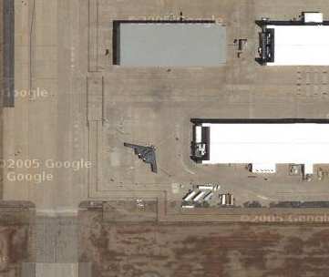
Google Maps – Plant 42 in Palmdale, California
See if you can find the B-2 bomber….
Found by E. Campbell via O’Reilly
By John C Dvorak Friday June 3, 2005

Google Maps – Plant 42 in Palmdale, California
See if you can find the B-2 bomber….
Found by E. Campbell via O’Reilly
 For Kindle and with free ePub version. Only $9.49 Great reading.
Here is what Gary Shapiro CEO of the Consumer Electronics Association (CEA) said: Dvorak's writing sings with insight and clarity. Whether or not you agree with John's views, he will get you thinking and is never boring. These essays are worth the read!
© 2008 Copyright Dvorak News Blog
Bad Behavior has blocked 9420 access attempts in the last 7 days.

OMGZ ITS A STEALTH FIGHTER JET!!!111
This is about as big a deal as knowing the location of Air Force One.
May I suggest watching the Discovery channel? I’m sure they have had a show in the past about the stupid thing. The images on the show would be much better then any stupid image from Google.
Even if the military didn’t want people knowing the location of the jet I’m sure they have like 50. I also sure their not all at one location.
Oh and China has much better images. After all… They can get updated images… Instead of ones that are… Years old.
It isn’t a big deal. It also isn’t cool. I have a book – “The Encyclopedia of Modern Warplanes” By Bill Gunston. As is the same with a ton of other planes (and any major US military jet) he has a entire page of infomation about the stupid thing. I’m sure he could write a entire book about it, but the format of the book only allows one page per plane.
Ya this comment is overboard, but it’s quite annoying seeing this show up in a billion places. Even more annoying is smart people posting about it. Just another one of those “Hey he is blooging about it, so I should” I hate to say.
Boy, this smacks of carelessness on someone’s part, eh? I bet that thing doesn’t stay there long!
What other lonely looking locations might harbor such goodies? Anybody have a list?
I haven’t fiddled with any of the satellite photo providers since M$oft did it — and their images certainly are over 9 years old — because the view of our home is clearly before we re-roofed!
The vendors to Google have shots from our neighborhood just about 17-19 months old — judging by the early stage of construction of my new neighbor’s home and, that my father-in-law’s 5th wheeler is parked behind our workshop.
The increased accuity has made it possible for me to try something I’ve only read about — satellite archaeology. The photos stretching from the ancient Spanish pumice mines at the nearby edge of the Caja del Rio plateau just manage to identify the shallow tracks of El Camino Real across the southern half of the plateau to the village of La Bajada. There were several variations on this theme; but, I’m looking forward to exploring along this local section.
Take a look around, Anthony!
Anthony. No more annoying than having spent 2 minutes reading your unnecessary and unwarranted complaint.
At that same location you can see a U2 and an SR-71 as well. Area 51, however, does not have a high res zoom. : (
Maybe it’s just B-2-flavored plywood.
Anthony-
I think you are missing the point…these images are supposed to show the top of buildings, roads, lakes, etc,etc, not a B2 Stealth Bomber! The quality of the picture or rather or not The Discovery Channel has done a show on it or not (I’m pretty sure they have) is not important. This is like an Easter Egg hidden away in the lastest Star Wars movie…not really importanat as the movie but nice to see.
I agree that a million differnet bloggers are going to copy and post a blog about it, but just do as I do and a) only read good blogs and b) ignore it if you see it again.
my 2cents.
Wali
Doesn’t it seem odd that all these military installations are renderred with high-res pictures (whose color tilts toward the brown). Then zoom out and see the surrounding civilian areas (with bright greens) at much lower resolution.
Who’s scheduling these satellites, and have their “vital fluids” been compromised?
If people want to look at the cool factor I don’t much care (and I suppose I can’t tell from John’s post what his point of view is), however all these people that seem to think its… A breach of security or whatever are short sighted.
Not to mention the plane is 20 some years old…
Isn’t this a F-117 Blacknight?:
http://maps.google.com/maps?q=Plant+42+in+Palmdale,+California&ll=34.623402,-118.091816&spn=0.005161,0.007918&t=k&hl=en
I would imagine the US army has plenty of such images of well, of anywhere they want.
The color difference … I think Google send those to the US government for approval and got a doctored version in return, obfuscating defensive structures and the like? (me guessing)
In this day and age, its difficult to imagine any army planning to invade the US not having their own satellite images. If you planned to attack you would probably have this info in advance from your own trusted sources instead of trusting a “do-gooder” company from your enemy country riding high on the stock market. I’m guessing these images are fun but pretty useless for any potental attackers.
Yes, in fact the answer to “Can you spot the B2 bomber?” is “NO!” Hehehe