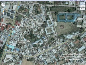
I’m not sure why this map has not been well researched by the media, but according to most sources this is where Osama was taken down. It’s a large complex in an area where helicopters could arrive. It’s in the middle of town near a slew of hospital and schools lessening any chance of Predator attacks. The town looks pretty pedestrian and common for a mid-sized city. You can find this map on Google maps by searching for the bus stop near the compound: “gammi adda stop abbottabad, pakistan” and look around for yourself. A less detailed map is shown in this post in the Atlantic, which is where I found the bus stop.
That said the fans of Google Earth and the London Telegraph found a more wide open place here which matches complaints by the State Department regarding the proximity to a military academy:
View Osama bin Laden is dead in a larger map
Where are the Pakistani’s and their cell phone cameras anyway?


Jeebus! No wonder it took you Yanks so long to find him. Half of you can’t even find him now.
As I’ve said before – I’m stunned that he was in Abbottabad. It was hard for me to describe how bizarre this is but I think I found a simile:
It’s like the #1 person on the FBI’s Most Wanted List building a conspicuous house in Quantico.
I can only conclude that the Pakistan military was protecting him. Osama would never have moved there if he thought the military was after him.
But he might move there if he thought the US would never have the nerve to fly such a risky mission into the heart of the Pakistani military. More significant than the facility in Abbottabad, is the major air-force base in Rawalpindi which, in air distance, is right on the doorstep.
The military was protecting him makes sense. Because it explains one big problem with the story. SO they get into a firefight with Seals, etc. They had lots of cameras on the ocmpound. Why didn’t they have a tunnel to escape thru upon the first sight of trouble?
Look at this link:
http://en.wikipedia.org/wiki/File:Kashmir_map.jpg
It shows Islamabad; Pakistan’s North-West Frontier Province & Federally Administrated Tribal Areas; the Northern Areas along with Jammu and Kashmir; China; India; New Delhi and Afghanistan.
The Karakoram Highway mentioned above goes from Abbottabad through the Northern Areas to China. A railway and possibly an oil pipeline will roughly follow this highway from the Arabian Sea to China. There have been reports that Chinese troops are in the Northern Areas of Pakistan. The Chinese are key supporters of the Pakistani military.
Could this be a flash point of a future war?
As old as I am, even I know that picture is not of the place the DOD says he was in. I found it on Google Earth early this morning using the pic from the DOD as a reference.
Come on, are you testing us?
Down, story. Down! Bad story, bad!
nice tanks navy seals team 6